
We were recently featured on the podcast N2backpacking talking everything from the Benton MacKaye Trail to our favorite pieces of gear. Give it a listen when you have an hour to kill!
http://n2backpacking.com/episode-28-the-benton-mackaye-trail/
We were recently featured on the podcast N2backpacking talking everything from the Benton MacKaye Trail to our favorite pieces of gear. Give it a listen when you have an hour to kill!
http://n2backpacking.com/episode-28-the-benton-mackaye-trail/
This post is kind of a wrap up of the BMT by the numbers. I'll be publishing a post over on my Appalachian Trials blog very soon and will post a link to that when it's live. For now, here's a breakdown of the statistics from our thru hike of the Benton MacKaye Trail.
Benton MacKaye Trail Facts:
-The trail is pronounced Benton "Mac-Eye", not "Mc Kay" as many people think.
-The length of the trail is different now. In 2012, the trail terminus was moved from Davenport Gap to Big Creek Campground since it's kind of dumb to walk through the campground, up to Davenport Gap, and then right back down to the campground to get a ride since there is very little traffic at Davenport Gap. It was 286 miles, then 283, and now it's about 290 due to a reroute. More reroutes have been completed, but not signed or made official as of yet. The trail will be closer to 300 in the near future.
-You can do a loop hike of this trail with the Appalachian Trail. If you hike the AT/BMT loop, it is 500 miles. We technically are 500 Milers since we have done both trails. I thought this was pretty cool!
Our Hike - By the Numbers
-Days hiking: 20
-Zero days (days not hiking during the 20) taken: 1
-Nights spent sleeping indoors: 4 - Days Inn of Blue Ridge, GA; two nights at Green Cove Motel; one night at Tapoco Lodge
-Nights camping: 16
-Nights camping alone: 13
-Days walking in the rain: 1
-Nights camped in the rain: 4
-Biggest Crowds: 15 people at campsite 81 and 12 people at Laurel Gap Shelter in the Smokies (Memorial Day Weekend)
-Days we saw people: 20 - this is not common on the BMT. Many trail journals I read most people went days without seeing a single soul.
-Miles per day hiked (on average): 15.26 (not including our zero day)
-Pack weight: Sprinkles ~20 lb fully loaded; NoKey ~ 24 lb fully loaded
-Body weight lost: Sprinkles - 6 lb, NoKey - 20 lb.
Gear to Change
For both of us, most of our gear worked incredibly well! For NoKey, we are going to switch him to a full length sleeping pad, as he was using a 3/4 length Thermarest Prolite and had quite a few uncomfortable nights. He also splurged on a luxury item yesterday - an inflatable pillow. By swapping out his bug net for the pillow, he'll never even know he's carrying it! For me, my MSR Seagull pot was just too small for the homemade meals I assembled before leaving. The meals and water would completely fill the 750 mL pot and stirring them was nearly impossible. I have upgraded to the GSI Pinnacle Soloist, which has a great nesting system that includes a stove bag, room for a fuel canister up to 220 grams, a cup/cozy, room for a lighter, my Swiss Army Knife, lid, and dual purpose bag to store it in. I'm pretty excited since now I have a capacity of 1 liter. The extra 250 mL will make a huge difference! I will also add some clothing to my bag and carry a pair of capri pants, as there were three nights on the BMT that I was absolutely freezing in my 36-degree down bag.
As I mentioned above, my summary of the BMT will be coming over on my Appalachian Trials blog and I will be sharing the link with you all soon. We are really looking forward to hitting the Finger Lakes Trail very soon!
Our last day is finally here!! Everyone was up and moving around at 7:30 and we were in a hurry to get moving. Even though the forecast predicted rain, we woke up to sunshine and we were in a race with the weather. Mt. Sterling, the highest point on the BMT at more than 5800 feet, was waiting for us and I wanted NoKey to get the view I think is the best in the Smokies. We did a quick 5.8 miles in less than 2.5 hours to get to the top by 10:45 am. We were definitely rewarded!

Looking at the AT from Mt Sterling on a nearly perfectly clear morning!
From here, we got a few texts out to my family to let them know we would be done by 1:30 and shot off down Baxter Creek Trail for a 4000-foot elevation loss down to Big Creek Campground.
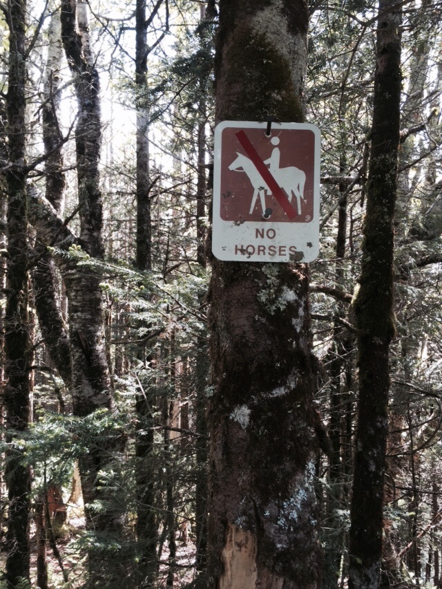
Finally! We won't be walking in horse poo!!
We made it down the hill in 2 hours and finished the trail at 1:20 pm. There were tons of people picnicking in the day use area, so we were able to get a photo of the two of us together at the terminus of the BMT with my homemade sign. It was a great feeling to have sunny skies to finish this tough trail.

We did it!
I will be writing a recap of the BMT in a few days and sharing it with you all. This trail had three very distinct sections, broken up every 100 miles or so. It feels great to be back home in a temperature controlled environment with comfy beds, but two more trails await us this summer!
It rained all night and finally tapered off just around sunrise. We got out of the tent at about 7:50 and wiped everything down as best we could before setting out for, on paper, looked to be a tough day. We began by climbing to the top of Hughes Ridge and meeting the Enloe Creek trail for a few miles before finally heading back downhill. The trails were slick, but in great shape considering the weather. We forded Enloe Creek and NoKey actually managed to rock hop the whole thing! We passed a few pretty cascades before coming to campsite 47 and beginning our next climb.

A beautiful waterfall in the remote Smokies Backcountry.
The next climb to Beech Gap Trail started steep, but leveled out near the top giving us a much needed break. Towards the top of this 5000-foot peak we were once again walking in the clouds, but didn't mind because it kept us nice and cool. From here we had a steep downhill of nearly 2000 feet of descending down to Straight Fork Branch, where the sun came out for a few minutes and we had a quick lunch before beginning our last big climb!

Walking a verdant path through the high clouds in the Smokies
After lunch the clouds rolled back in and we had to climb nearly 3000 feet yet again! We took our time and took lots of breaks at some beautiful springs, filling our water as we went. This has been such a nice way to end our trip, not carrying so much water! Near the top of our climb at the junction of Beech Gap and Balsam Mountain, the trail levels out as we walked through a spruce forest at nearly 5600 feet of elevation before heading downhill into Laurel Gap shelter.

A surprisingly full house for a Tuesday after a holiday!
We camped with 12 people at Laurel Gap and met lots of interesting people! It was so nice to stay under a roof and be social for the night. Just around 7 pm the rain started to fall for a few hours - a nice way to fall asleep knowing our tent had been dried out and we were dry, listening to the rain fall on the tin roof. A great way to spend our last night on trail!
Another 9:30 am start this morning! We woke up alone in camp as Eagle and Fat Camp were long gone! We had an easy warm up walk to campsite 57, the last home of Horace Kephart, before beginning our uphill for the day. It wasn't ever too tough and we passed some very sweet horses about a mile from the top. When we reached the first of three summits near the top of Newton Bald, we met a Mountains to Sea Trail hiker. This trail runs from Clingmans Dome all the way to the Outer Banks, running 900 miles across North Carolina. We quickly made our way up as over the other two summits before finally heading downhill for the day.

Lots of names for just one footpath!
While we were cold on top of Newton Bald, our first 5000' peak of the trail, down the hill it got warmer and more humid as the sun finally came out. By the time we reached Newfound Gap Road it was close to 80 degrees. We had to wait for a few minutes for traffic to clear since it's Memorial Day today. We crossed and then had to walk up Towstring Trail, which is a nasty, disgusting horse trail and I can't believe the BMT doesn't just walk the road. We walked under power lines uphill in the sun in fresh horse shit for a mile before reaching the back end of the Smokemont Campground. We took a detour into the campground to use the running water. We both washed up and charged up our phones a little before heading up to Chasteen Creek.

Beautiful flowers on our walk today
We reached campsite 50, our destination, at 4:30 and decided to just go on the extra 2.2 miles to the next site up, campsite 48, to get a jumpstart on tomorrow. We followed Chasteen Creek up an old roadbed very similar to yesterday on Noland Creek. We reached this site at 5:30 and settled in for the night, alone again now that the holiday is over. Tomorrow is our last full day on trail and is by far the toughest on paper. We're hoping the weather holds out as it is a 50% chance of scattered showers overnight and most of the day!

Chasteen Creek Trail is pretty too!
We slept in a little later this morning and didn't leave until 9:30. We passed campsite 74 and it was still packed with kids running around. We were glad we stayed down by the lake instead! We had about 3 miles to do of ups and downs like the end of yesterday before coming to the tunnel at the Road to Nowhere. We walked through in a cool breeze and managed to avoid the piles of horse poop. That has been the most annoying thing about the Smokies' BMT is that it's most horse trail. When we came out at the other side the parking lot was completely packed and there were people everywhere! I guess that's what happens when you end up in a national park on Memorial Day weekend!

A rare photo of us together!
We did a little road walking here to our next trailhead and ended up following an old road bed uphill for the next 8 miles. The walking went pretty fast and we followed Noland Creek the whole way, fording it a few times along the way. People thought we were nuts for just walking through the creek with our shoes on, but it felt great to get cold feet for a bit. We took a break at campsite 61 and met a dad who had been hiking all day with three young kids. That's a brave man! They had a tough uphill day and the kids were overjoyed to be at the campsite. From here, it was just one more mile uphill before we finally began walking downhill for the first time all day.

Noland Creek Trail has so much water!
Since we already had wet feet, Pole Road Creek Trail didn't bother us. It was tough on our feet because the trail was so eroded and rocky, but we made it down the 3.4 miles pretty quickly. We crossed a really cool log footbridge and had only a quarter mile to our campsite for the night. We reached campsite 56 and met Eagle and Fat Camp. We had an awesome night hanging out with these two guys who kept giving us food and whiskey they wanted to get out of their packs as it was their last night on trail! We ate lots of chocolate and drank whiskey around a campfire until nearly 11 pm with these two guys. It was the first time we actually got to hang out with anyone in a campsite and we had a blast meeting them. We have another long uphill tomorrow morning and those two are getting up crazy early because they have to drive 8.5 hours home after the 13-mile hike out!

NoKey crossing Deep Creek on a foot bridge

Fat Camp and Eagle at campsite 56.
We had a pretty sleepless night at campsite 81 due to it being pretty chilly. For late May, the temperatures were easily in the 40s! We packed up and headed out of camp at about 9:30 for a long, but easier day in the Smokies. About 3 miles in we saw our first hikers of the day headed the other direction and reached campsite 77 soon after. After a quick break for a snack, we began walking old roadbed for the next few hours. It is easy to daydream about how this area must have looked before everyone got kicked out for the building of Fontana Dam back in the early 1940s. We passed several unlabeled side trails and that usually indicates a cemetery on this side of the lake. Walking through this area now it is hard to imagine that 70 years ago thousands of people lived here.

One of many cascades along the trail today
We took a long lunch at campsite 76 right near a boat launch. We then followed the lake for a bit before climbing up and away since the road we had been walking now disappeared straight into the lake! We reached our next camp in less than an hour and met the roadbed yet again for a few easy graded miles. An hour after leaving Chambers Creek we ran into a group of about 10 young guys anxious to get to campsite 98. When I told them we left it an hour ago they all looked like I had punched them in the stomach! We told them we had walked about 14 miles already today and they looked shocked.

A canoe on Fontana Lake
We had a series of PUD's for the next 4 miles- pointless ups and downs. We basically walked along a ridge, swung around one side of the hill, and crossed to another. We finally came down into Forney Creek at about 5:30 to our campsite at camp 74. We set up a bit away from everyone else since they were cooking food and smores on a grill. Bears tend to like that sort of thing! We have a big day tomorrow also, and a wet one! We are walking three trails tomorrow, all of them with the name "Creek" in the title! We are hoping for a warmer night and better sleep tonight.

More cascades leading down into the lake
Today we ate a huge breakfast thanks to Tapoco Lodge and left the hotel with lighter than anticipated packs thanks to them holding a box full of stuff for us. NoKey hasn't been eating as much as we planned so sending some food back has been nice. We walked outside the lodge and caught a ride to Fontana Dam thanks to Ed from Missouri, who was out driving on the Dragon and killing time. For those who don't know, U.S. 129 is called The Dragon, 300 curves in 11 miles, and attracts people from all over the country who want to say they drove it.

FINALLY!
We hit the Dam at 11 am and thanked Ed for the ride. I gave him a bit of a history lesson about the area during the trip too. Thanks again, Ed! We began walking across the dam and into the Great Smoky Mountains National Park! The BMT follows Lakeshore Trail the first 35 miles and I enjoyed seeing familiar trail again. I also gave NoKey some history about the area while we took photos of everything from abandoned cars to old homesites and chimneys. When we made it 5 miles in we were at campsite 90 and it is absolutely packed - to be expected since its Memorial Day weekend. We headed on down the trail to campsite 86, which is on the site of the now abandoned town of Proctor. We had late lunch here and headed up and over Welch Ridge to campsite 81.

One of many abandoned cars along the trail
We got to 81 and met a large group there. We said our hellos and set up our tent to dry out from the wet night we had before heading down Slickrock. Tomorrow we are expecting busy trails since its the swing of Memorial Day.

The chimney of an old home is all that remains standing.
We woke up to the same rain that had been pouring down all night. We were camped at 4900 feet so the rain plus high elevations made for cold temperatures. We didn't leave camp until about 10:30 since we were waiting for the rain to abate. We were walking downhill through brush and undergrowth so our legs, socks, and shoes got pretty wet. We had quite a few ups and downs this morning before running into some day hikers about 3 miles from Farr Gap. We had a quick lunch and then headed to the gap and the infamous Stiffknee/Slickrock Creek trail.

Always a comforting sign to see when you sleep with your food in your tent and you're not even half a mile from camp!
Now I had heard rumor this trail was rerouted to miss this nasty creek, but if it was we didn't see it! We started down steeply and immediately understood the name Stiffknee Trail! Our packs are nearly empty and this thing was steep! We kept dropping down and crossing numerous creeks, fighting our way through numerous blow downs and through brambles. The trail got muddier and tougher to walk and we eventually reached a junction that let us know we were actually still on the right trail (miraculously!) all of a sudden we were standing on a rock with a sign reading Slickrock Creek and we knew if there was a reroute we definitely were not on it. We forded the creek, which was about thigh deep, and shook out on the other side.

We finally saw rhododendron blooming today!
By now we were exhausted, but no campsites were listed in our book and we just wanted to be both dry and warm, as the sun still had not come out and we spent most of the day walking in clouds. We climbed up Ike Branch to Yellow Hammer Gap and looked for the side trail to Tapoco Lodge, but it hasn't been built yet. Up we went some more crossing Ike Branch about a thousand times before finally reaching the top and crossing it about a thousand more times on the way down. We reached the Tapoco Trailhead at Cheoah Dam (the one they filmed The Fugitive on) and finishing our day with a half-mile road walk to Tapoco Lodge.

Cheoah Dam - they filmed The Fugitive here.
When we saw the lodge we were elated! A big sign greeted us and we walked through the gates and were immediately awestruck. This lodge only became hiker friendly a year ago, and walking up to it it was more like a private club or a five star hotel. We checked in and couldn't have been treated better. We had a gorgeous room, a hot shower, free laundry, and a brick oven pizza place on premises! We ate a huge salad and pizza with some beers, had cleaner clothes than we have in over 100 miles, and climbed into the biggest bed I've ever seen to sleep. What was a tough day turned into an epic evening!

An epic evening awaited us here!
We were sad to leave Tubby behind at the Green Cove Motel and Store, but we had places to go. We began with a 1.4 mile was back to the trailhead at Telico Fish Hatchery. From here we walked old road bed 95% of the day. Our first old road walk was up the Sycamore Creek Trail. We walked nearly 6 miles up a gradual hill before hitting a forest service road and climbing all the way up to Whigg Meadow and our first actual good view on the BMT! We met an older couple here and talked to them during our lunch. When we did the extra quarter mile up to the top we met some grad students looking to place bat boxes for research purposes. We had an easy hike down to Mud Gap and the Cherohola Skyway where we had a piped spring waiting on us!

Looking up at Whigg meadow
Haha, I'm only kidding! The book said there was water here, but you know by now there wasn't any! It was only 1 pm and we had already done 9 miles, but it was starting to get hot! We passed through the site of a former rock quarry that now looks like a bald and walked down to a forest service road before heading back up to meet the Cherohola Skyway again. We had another beautiful view at Unicoi Gap before heading back into the woods and following an old jeep road for a little while.

Walking through the old quarry
About 2 miles in we met Kyle who was out hiking with his sister's dog. It turns out he is friends with All Smiles, a man we hiked with for a few days back on the AT in 2012. Once again, the trail community is so small! We continued on and found a wonderful piped spring and chugged as much water as we could before filling up our bottles and heading on our way. We left the jeep road about a mile later and started climbing. We spotted a great campsite but there was no water nearby so we kept moving. We crossed two small streams and came to a large campsite about 1.5 miles later. We thought this was our destination, but it turns out somewhere in the weeds was our campsite and we had passed it up. This meant I had to walk back half a mile for water (a mile round trip for those keeping count at home!) we also fixed a trail sign that is obviously very wrong here. No blazes means it's easy to get turned around in a wilderness area, so the correct signage now will help!

Even more views! This is Unicoi Gap on the Cherohola Skyway.
Zero day at Green Cove Motel! A zero day means you don't do any hiking and I didn't expect we would have any days like that on this trail. After the nightmare that was yesterday's hike we definitely needed a day off and we slept late. We fell asleep at about 9:30 last night and stayed in bed until 10 this morning. We wandered down to the store and poked around for a bit before the owner, Tubby, offered us some of her leftovers from dinner the night before. We had a huge breakfast of cube steak with country gravy, mashed potatoes, peas, and Mac and cheese. Tubby comes from a family of eight, so she always makes enough to feed an army she said. We sat with her for about an hour talking about just about everything before we left her alone for a while.

Breakfast of champions on a cool table Tubby made from YooHoo caps.
I made a few phone calls, the first to Rick and Brenda Harris - BMTA board members and maintenance directors. I asked about trail conditions coming up and Brenda assured me that our next section had been worked on very recently. She was aware of the condition of the trail we hiked yesterday and told me they were working on getting it cleared. Since we were in a wilderness area, they cannot use anything like chainsaws or weed whackers. The ranger district here is focusing on maintaining horse trails this year so the BMTA is kind of on their own. I then called the Tapoco Lodge and confirmed we would be there this weekend so we definitely would have a place to stay.

Bloody and battered hiker legs from the tough day yesterday.
We ate huge dinners and then lounged around the rest of the night. Even though there are no laundry facilities here, we were able to wash our clothes in the sink with a bar of soap and get them mostly dry for tomorrow. Laundry on this trail is few and far between!

Drying laundry hiker style- chasing the sun around the parking lot!
For anyone looking for a quiet, clean, relaxing place to get away I highly recommend Green Cove Motel. This place is out in the middle of absolutely nowhere. There is no TV or phone in the hotel rooms. No phone service works here. The windows and doors open up back onto the Tellico River and men are outside fishing all day long. I was telling NoKey this is how it must have been doing a long distance hike 30 years ago - walking nearly deserted roads to get to town, get a stack of quarters, and use the pay phone to call places. Tomorrow we go back into the woods with a guarantee of better trails and nice weather. It was been a perfect day off!

Green Cove Motel- middle of nowhere and heaven on earth!
We started earlier today, about 8:30, and began our first climb of the day to Cantrell Top. The sun came out for the morning and we had some easy ups and downs until we reached Hipps Gap, a dry (shocker, I know!) campsite. From here we had to start climbing but our day looked easy on the map and profile because once we were up, we were on top of the ridge. We couldn't have been more wrong.

This is a North Carolina State line marker from the early 1800s
After some crazy steep climbing and an attempt to get water that didn't pan out, we reached Moss Gap, noted for the hairpin turn in the trail and a tree marked with a giant X indicating there is water a mere half mile off the trail. We decided to head up and get water at one of the few campsites if we needed it. This is where our day turned to utter shit. For the next four miles we bushwhacked through immense blowdown. The trees were thankfully blazed and there was a faint path of where people had gone through a week ago, but otherwise we were completely on our own. For four miles, which took us three hours in the pouring rain, we climbed through branches, grass up to our necks, and thorns shredded our legs. Any evidence of campsites and unmarked side trails was completely obscured. It looked as if a tornado had hit the mountain.

There is a trail in here... Follow the blazes and make your own path!
When we finally hit Rocky Top, we had about half a clear mile before coming to another hairpin turn at Sledrunner Gap - the halfway point of the BMT. Now, we were coming downhill in the same shit we climbed on the other side. This side was even worse because it followed and crossed a stream multiple times. Rhododendron were down everywhere and even harder to climb through. Again, all campsites and mile markers were completely wiped out due to the utter disregard for trail maintenance. At 4 pm we had to make a decision. We were at a trail junction where the BMT went up and trail 180 looked to be going down. The map indicated in about 6.5 miles we could be at the same location 5 BMT miles would take us to. We had been hiking for 7 straight hours without eating or stopping and we decided the road might be longer, but at least it was clear.
Which way to go now...?
This decision changed our entire day. Trail 180 was an old roadbed that appeared to have a lot of recent foot and horse traffic. We got down the 1.5 miles in less than 40 minutes. We came out at a campsite and ate a quick dinner before walking FS 126, a gravel road that went up and between two mountains before coming downhill to Tellico River Road. It was about 6:50 when we finally made it to the road and we knew that the Green Cove Motel was 1.4 miles from the trail. We walked about a quarter mile before coming to the Sourwood Campsite and some people told us the motel wasn't far. They even drove us down. When we got to the store, the woman working there, Tubby, was only there just to stock the place. She said we were incredibly lucky to catch her as she had just got back from a trip to Knoxville and was shutting up for the night. We grabbed snacks and sodas and checked in for two nights as we were utterly exhausted.
We woke up to rain and decided to stay in the tent until it stopped. About 9:15 it sounded finished and we began to pack up, leaving camp about 10 am. Since we once again had to follow water we had no choice but to hike a 14.4 mile day. It's really starting to get annoying having to hike a certain way on this trail! Since we know most water sources aren't even on trail, the map I bought in Blue Ridge has been helpful, but it's still not fail safe. We hiked out of camp carrying more than 9 liters between the two of us.

NoKey crossing Coker Creek
Climbing up and over Unicoi Mountain left us saying goodbye to the John Muir Trail we had been following and took us on an easy climb following old roads to highway 68. After a short lunch and some foot surgery on both of us, we began walking again on the nicest trail we have seen yet on the BMT! This part of the trail for several miles is also dirt bike trail, so maintenance was great! After reaching a forest service road that maintains the power lines, it started to turn into more trail like conditions. We were supposed to pass a campsite with water and once again never saw it, or any evidence it had been there. We reached the top and saw an old homesite and a nearly dry spring. We attempted to get water but it was mostly mud. Thankfully, the other side of the hill had a gorgeous spring and we were right at the source! We completely filled out bottles and camelbaks and headed down the trail to Tate Gap, our campsite.
Looking ahead at our last climb of the day.
When we got to the gap, we had read that there was a secluded and sheltered site 0.3 off the old road. I left my pack with NoKey and went to scout it out. There was a nearly dried up spring and a HOUSE with garbage everywhere at the supposed site. I went back to the gap and we made camp right there on the trail. This is how the BMT works I guess - no water and no camps... Make your own!
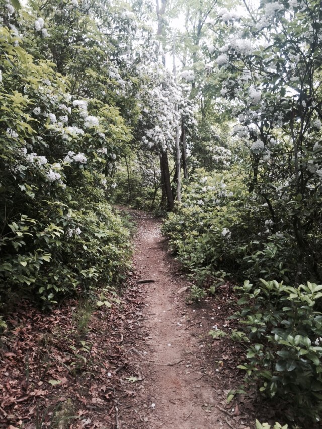
At least we had some pretty mountain laurel blooming!
We didn't leave Reliance until 1 pm, mostly because we are ahead of our schedule and also because Dan at Reliance Fly and Tackle had to go to town and offered to pick NoKey up some antibiotic ointment for his feet. His blisters are getting infected and needed some TLC. While we were waiting on the back porch of the campstore we missed a heavy and short rain storm. We were definitely glad to be packed up and dry!

Walking along the Hiawassee River - the lowest point on the BMT
We had an easy walk along the John Muir Trail leaving town, mostly flat and downhill where we followed the Hiawassee River for a few miles. Our first big climb was supposed to take us to a high point where we could get a view of the river, but the trail had been rerouted due to logging. Again, no views on the BMT. Once again we were reminded how spoiled we were on the AT thanks to the National Scenic Trail Act of 1968. We did finally have a cell phone signal at the top of this one and were able to get and receive a few texts.

A pretty cascade from Wildcat Creek
From here it was up and down with a pretty cascade and a bonus side trail a group of fishermen told us about. Then, we climbed though a ton of rock formations known as the Narrows before coming camp at Loss Creek. We have a big creek crossing first thing in the morning followed by some uphill, so this is a great stopping point. The weather is calling for an 80% chance of rain tomorrow so I hope we miss that!

These pretty flowers are called Indian Pink
Today would have been the most miserable day ever if not for Red! He slack packed us, which means he takes all our gear except for the packs, our lunches, and our water. We did a quick and fast 19 miles into Reliance, Tn to our drop and next campsite.

The dam at Ocoee River
The trail today, however, was something else entirely! This is honestly the most miserable hiking we have done to date. Our hike began hot and humid from the Ocoee River and up Dry Pond Lead in the Little Frog Wilderness. It wasn't a difficult climb, but the trail was extremely overgrown and by the time we reached the top we were both bloody and hot. Sweaty legs itch when they're scratched so badly!

There was a 100-mile trail race coming through here in a few hours... Wild Trail is right!
The next part of our day took us into Cherokee National Forest. This area had a prescribed burn last year, which meant for six miles we had nothing but dead trees and thorns. The sun came out and scorched us. Just when we though it couldn't get much worse, we started walking on road beds, which had thigh high grass and ragweed. No tree cover and black widow nests every few feet added to our misery. When we reached the end of the road, we went back into the dead forest, losing our way several times before finally making it downhill to Lost Creek. On the positive side, we hit our 100-mile mark today!

A field we walked through on the old FS road walk.
It was an easy 4 miles from here into Reliance, a teeny town on the Hiawassee River and the lowest point on the BMT. We made our way to the Reliance Fly and Tackle where our drop box waited and campsite was reserved. The hospitality here is amazing and the campsite is inviting. Once again we got set up just before it started to rain. We had cheeseburgers and beers at the store and a local woman gave us homemade blackberry cobbler. This trail just keeps getting better. What could have been a miserable day was made so much better by the kindness and hospitality of others.

The view from our tent tonight!
Today was going to go quickly because we knew showers and the Ocoee River were waiting for us! We started out our day by seeing two turkey hunters on horseback passing our camp just before we left. We then had a short and easy climb up, you guessed it, and old fire road up to Hemp Top. No view here, so we kept going until we made it to the state line at approximately 10 am! We filled up our water and then made the steep and surprisingly quick ascent on Big Frog Mountain, 1100 feet in a mile.

Welcome to Tennessee!
From here it was nearly all downhill into Thunder Rock Campground and we made it down by 3:10. When we came into the large campground, there was only one RV there, a tent, and the camp host. I asked someone where the pay station was, paid up, and went for the bathhouse. This place had HOT showers! I even did some laundry in the shower but it didn't really dry due to the humidity.

The Ocoee River behind our camp.
While we were laying out clothes, a man came by and asked us if we were Benton MacKaye thru hikers. We told him yes and he said to come over for beers later. We met Red and his wife, their friends who had recently relocated to NC and their son. We also officially met the camp host and her son. We hung out until 10 pm, which is WAYYYYYY later than hiker midnight ;)

A picnic table at our campsite! Yay!

Water - does a body good!
I know what you're thinking from the title of this blog... "Yes, I know water is important! I always drink plenty!" So do I... Usually. On our fifth day on the Benton MacKaye Trail we ran into a dire water situation and I wanted to write this bonus blog about how important your water truly is.
When we left Blue Ridge, GA on our fifth morning, we were going to be doing a six mile road walk through vacation cabins, neighborhoods, and farmlands. Our guidebook indicated that this valley walk didn't have a 'good' water source, so we walked out of town with approximately 3 liters of water a piece. When we finally finished our road walk and stopped for lunch, we knew our book said water was 0.8 miles away on a side trail. We drank most of it on the hot exposed roads and only had about 1/2 a liter of water between us (17 ounces). We attempted to find this water source in two locations where it supposedly was, but recent development and cabins built on this mountain pretty much wiped out the springs. No problem. We had a few sips and decided to go up and over the mountain in front of us, approximately 2.4 miles, to the next source.
We arrived at the next gap and began surveying the situation. NoKey followed a trail down into a gulley and there was nothing there. We walked every direction we could and no water. Okay, 1.2 miles to a campsite and water source, again up and over a mountain!
We arrived at McKenney gap and not only was it NOT a campsite, not on a road (as the book suggested), and had evidence of bear activity, there was not a single place that even looked like there was water. Again, some old trails all converged here so we wandered around and found absolutely nothing. We didn't have a choice other than moving on for the night. This is where we had originally planned to camp, but the fact that I had physically seen a bear AND two coyote coming up over this ridge made me think again. We drank the last of our water and powered up to the next gap where there was supposedly a stream crossing.

Something chomped this VERY recently.
On the way into Hatley Gap we spotted some water close to the trail. We made the decision to bushwhack down the hill and make ourselves a way to fill up a bottle out of the spring. We drank a few bottles a piece and walked on our way hoping to find a camp.
Why am I telling you all this? Because I wanted to let people know that not all trails like the AT or trails in the Smokies where water is guaranteed just because a campsite is established. Our first night on the BMT we also didn't find our supposed water source and had to trek back up the hill for water. When you see water running make sure you have enough! We have Sawyer Mini filters and could have avoided this situation today if we had thought ahead and said "well our water source might not be there anymore." Always have extra water because at the end of the day it's easier to dump out water than it is to seek it out!
With heavy packs and full bellies we made our way up highway 76 for a hitch back to the BMT. We only tried for a few minutes before being picked up by a nice guy named Justin Walker. He actually had travelled to Millinocket when he was in his late teens! Small world. We began our walk into the most secluded portion of the BMT by first doing approximately 6 miles of road/backyard walking through a new development of vacation cabins all over the side of the mountain. This is the reason you should celebrate national trail acts! Every trail might have turned out looking like this one.

Wait... AT community?! What about the BMT?
The downside to this, and that's a topic for another blog, is all the development completely wiped out our water sources for most of the day.

A farm with cows on the road walk.
After finally getting back into the woods, I saw a bear and two coyotes in the closet parts to the cabins. I guess they really do stay close to people. Scat covered the trail and trail signs had been chomped by sharp teeth! After walking a few more miles and finally finding some water, we found a perfect campsite at Hatley Gap and built a fire to scare away any critters that might stop by tonight. The weather is supposed to cool off the next few days so we are hoping to get in bigger miles now that humidity is finally on our side.

NoKey at our great camp with our fire.
The Game Changah!
Today started out a little earlier than day 2 but we thought we might get afternoon rain. Add to that the fact that we wanted to see if the Tococca Riverside Restaurant was open and we were motivated to move! We were walking out of camp and found that just a tenth of a mile further was a campsite covered in lady slippers! The first part of our day was overcast, but uneventful. We spent most of the morning following horseshoe prints down to the gap at Route 60. We ran into some day hikers at the gap and figured we would see them again. By now it was 12:30 and hot. We had two mountains to climb and the first was rough but we met more day hikers at the top. They said we had an easy 5 miles to the road but we knew we still had to climb Brawley Mountain to the fire tower. We got to the top in the searing sun and 90-degree temps to find that the tower wasn't accessible and the view was dismal. We had mostly downhill walking from here, following a few old roadbeds. We reached Dial Gap very quickly and began our first long road walk of the hike. We reached the Tococca River and found out the restaurant was indeed open!!

Hike n eat - my motto
We went into this incredibly nice restaurant smelling awful and looking even worse. This place is NICE and we were out of place. We went in and asked if we could sit on their patio and these people couldn't have been nicer! They took our packs and put them away so we could enjoy our dinner. We both got huge fried chicken dinners with mashed potatoes and green beans, the chicken smothered in country gravy! We also had spicy fried pickles and I polished off a peach cobbler. This meal was a huge game changer.
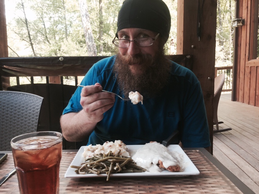
NoKey enjoying fried chicken with some iced tea!
By now, it's 5:15 and we have 3.9 miles of road walking to the next place we could get into the forest and camp. This walk was long and hot, but we got it done by 6:30. We camped just upstream from Fall Branch Falls. It was beautiful, secluded, and quiet! We took hiker baths and did hiker laundry with our Dr Bronners and had an amazing night surrounded by fireflies in the North Georgia Woods. We pulled 18.7 miles today and our feet were feeling it!

Fall Branch Falls near our camp for the night.
Today started out late, but we actually saw people! Day hikers passed by us as we were packing up camp and we hiked past them pretty quickly. Most of our early part of the day was downhill and we got six miles done before lunch time. After lunch at the Toccoa River swinging bridge, we started our big climbs. As we were nearly to the top of Toonowee Mountain we saw the only person who has actually asked us if we're thru hiking.

Tococca River Swinging Bridge
After summitting, we headed down to Hwy 60 - our first road crossing of the trip. We stopped at the bottom and there the two day hikers caught up to us, they were headed home and we had two more mountains to climb. The first climb up to Wallalah was really tough and it took a while, but the final climb of the day up and over Licklog Mountain was much easier.

The view from 3/4 the way up Wallalah... We can see it raining and hear the thunder in the distance!
We did 13.5 miles today and it was tough, but we had no choice since there isn't really a lot of water on this trail. Our campsite had a spring that was down a side trail and was nearly halfway down to the bottom of the 3400 foot mountain we're sleeping on tonight! Of other note, we hopped into our tent immediately following our dinner and noticed our tent had ripped in two places. We thankfully had a cell signal and I shot off an email to Henry at Tarptent. I'm hoping to hear back from him by morning so we can get our tent replaced!